Monday, May 5, 2025

The God Culture: Did Pinto Shipwreck In Batanes Or Luzon?

Timothy Jay Schwab who is The God Culture is a fantastic mental gymnast. He knows how to flip and tumble and shake off the words of a text which are incompatible with his thesis. 


Recently he has been fixated on Pinto's mention of "five large islands" to the west of the Ryukyu (that is Lequios) Islands. Here is the full quote from Pinto's journal. 

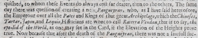
This Ryukyu island is situated at twenty-nine degrees latitude. It is two hundred leagues in circumference, sixty in length, and thirty in width. The land in itself is more or less on the order of Japan, a little mountainous in some parts, but it becomes more level in the interior, where many of its lush, fertile fields are irrigated by freshwater streams which produce an endless number of fresh crops, especially wheat and rice. There are mountain ranges where they mine a great quantity of copper which, because it is so plentiful, is so cheap among these people that they load junks full of it to sell in every port of China, Lamau,* Sumbor,’ Chabaqué, Tosa,” Miyako," and Japan, with all the other islands to the south, Sestras, Goto,” Fucanxi, and Pollem. In addition, all this land of the Ryukyus has great quantities of iron, steel, lead, tin, alum, saltpeter, sulphur, honey, beeswax, sugar, and large amounts of ginger which is of a much better quality and far superior to the ginger produced in India. They also have large forests of angely wood,"" jatemar,"' poytao,’ pisu, pine, chestnut, cork oak, oak, and cedar, from which thousands of ships can be made.

To the west, there are five very large islands which have many silver mines, pearls, amber, incense, silk, rosewood, brazilwood, wild eaglewood, and large quantities of pitch," though the silk is somewhat inferior to that of China. The inhabitants of all these islands are like the Chinese, and they dress in clothes made of linen, cotton, and silk, along with some damasks that they import from Nanking. They are overly fond of food, given to the pleasures of the flesh, and have little inclination for bearing arms, which are in short supply, from which it appears that it will be very easy to conquer them. So much so that in the year 1556 there arrived in Malacca a Portuguese in the service of the grand master of Santiago" by the name of Pero Gomes de Almeida,' bringing a magnificent gift and letters from the nautoguim, prince of the island of Tanegashima, for King John III, may his soul rest in peace, which in essence amounted to an appeal for five hundred men to help him and his men conquer this Ryukyu island, in return for which he offered to pay an annual tribute of five thousand quintals of copper and one thousand of brass. Nothing ever came of this embassy because the message was sent to Portugal on board the galleon on which Manuel de Sousa de Sepulveda was shipwrecked.

Pinto, pg. 300, Rebecca Catz, translator

As of this writing Tim has published four articles about these five islands. In the first article Tim concluded the five islands are the Philippines proper. 

The Smoking Quill writes again. Pinto’s “five very large islands” were not Ryukyu. They were Philippine islands west of Batanes—the true Lequios where Pinto was shipwrecked, the Isles of Gold, the gateway to Ophir. Every resource fits the Philippines and Ryukyu fails. 

https://thegodculturephilippines.com/pinto-s-resource-test-the-five-great-islands-were-never-ryukyu/

Never mind that the Philippine Islands are SOUTH of Batanes. 

In the second article Tim analyzed a map from 1799 that mentions five islands in the Philippines that do not actually exist. He says they are "clearly a symbolic preservation of Pinto’s “Five Very Large Islands” and his shipwreck near Lequios." 

In a 1799 map engraved and published in Venice by Antonio Zatta, we find yet another historical witness to the true location of the Lequios Isles: the Philippines. Zatta plots five islands west of Batanes where none exist today, labeling the region "Il Banco d’Argento" (The Silver Bank), adjacent to the Isole di Bashee and Babuyanes—clearly a symbolic preservation of Pinto’s “Five Very Large Islands” and his shipwreck near Lequios.

https://thegodculturephilippines.com/venetian-map-confirms-pinto-s-lequios-were-the-philippines/

Why would Antonio Zatta symbolically preserve "Pinto’s “Five Very Large Islands” and his shipwreck near Lequios?" What sense does that make and what is Tim's evidence proving that is the case? It is a bizarre ad-hoc speculative assertion that Tim has literally made up whole cloth.

Tim then proceeds to restate his thesis that the Philippines proper are the five islands mentioned by Pinto.

Yes — ALL FIVE major Philippine islands you've proposed (excluding Masbate) are geographically west of Batanes, affirming Pinto's directional accuracy if we interpret his account as referring to directional progression, not mapped coordinates.

Note that this analysis says one could consider all five major Philippines Islands to be west of Batanes only if you interpret west in a certain way.  

In the third article Tim brings up an irrelevant French map from 1752.

A full 47 years before Zatta’s Venetian chart and over a century after Pinto’s famous voyage, this 1752 French map silently affirms a truth colonial revisionists tried to erase: the Lequios Isles were the Philippines.

Just west of the Bashee Isles (Batanes), the map boldly labels:

“Les 5 Isles” — The Five Islands

They are plotted where no separate islands exist today, because they were never meant as literal, isolated rocks. Instead, they memorialize Pinto’s “Five Very Large Islands” — Luzon, Palawan, Mindoro, Panay, and Mindanao — recounted in sequence after his shipwreck and trial in Batanes.

https://thegodculturephilippines.com/the-french-knew-too-les-5-isles-west-of-bashee-pinto-s-lequios/

It's kind of strange that Tim is trying to prove the major islands of the Philippines proper are the five islands mentioned by Pinto by bringing up maps which post-date Pinto and show five tiny islands that Tim admits do not exist. 

In the fourth article Tim makes a clumsy reference to Finding Nemo which is not very clever, funny, or relevant. Maybe it's a reference to the sequel Finding Dory. 


Finding Pinto — The Five Isles That Never Moved

Maps featured:

  • John SpeedA New Map of East India, 1676

  • Nicolaes Visscher I / Peter SchenkIndiae Orientalis Nova Descriptio, ca. 1700

  • Willem Janszoon BlaeuIndia quae Orientalis…, 1640

"There were five very large islands, near to where I shipwrecked..." — so recounted Fernão Mendes Pinto in his famed 16th-century travels. Colonial academia later twisted this into an implausible link to Ryukyu, far to the northeast, where no such “five large isles” exist. But the maps never lied.

Across three of the most authoritative early modern European cartographers—Speed, Visscher-Schenk, and Blaeu—we find those Five Islands unmistakably preserved, plotted west and slightly south of Bashee and Batanes, hovering in clear reference to Pinto’s original drift account.

🧭 The Verdict

Over 150 years after Pinto's voyage, these maps still plot the same five-island formation, right where the shipwreck occurred—near Batanes, adjacent to Ilocos. There was no confusion among cartographers. Only later, as colonial narrative control tightened, did Lequios begin drifting north.

https://thegodculturephilippines.com/finding-pinto----the-five-isles-that-never-moved/

In the movie Finding Nemo, a clownfish named Nemo gets lost and his father has to find him. After a series of adventures they are reunited. This does not apply to Fernando Pinto. He knew exactly where he was. It was not the Philippines. In fact, he had previously been to the Lequios Islands. 

We proceeded on our voyage in the battered condition we were in, and three days later we were struck by a storm that blew over the land with such fierce gusts of wind that that same night we were driven out of sight of the shore. And since by then we were unable to approach it again, we were forced to make with full sail for the island of the Ryukyus where this pirate was well known to both the king and the other people there. With this in view we sailed ahead through the islands of this archipelago, but since at this time we were without a pilot, ours having been killed in the recent battle, and the northeast winds were blowing head on, and the currents were running strong against us, we went tacking with great effort from one board to the other for twenty-three days until finally, at the end of that time, our Lord brought us within sight of land. Coming in closer to see if it showed any sign of an inlet or harbor with good anchorage, we noticed a huge fire burning over to the south, almost at a level with the horizon. This led us to believe that it was probably inhabited and that there might be people there who would sell us water, which we were running short of.

As we were anchoring opposite the island in seventy fathoms of water, two small canoes with six men on board came rowing out from shore. They came alongside, and after an exchange of greetings and courtesies in their fashion, they asked us whence the junk had come. Our answer was that we had come from China, bringing merchandise to trade with them, if they would give us leave to do so. One of them replied that as long as we paid the duties that were customarily charged in Japan, which was the name of that big land mass outlined ahead of us, the nautoquim, lord of that island of would readily grant us permissionHe followed this up by Tanegashima, telling us everything else that we needed to know and showed us the port where we were supposed to anchor. 

pg. 274

Pinto could see Japan from the Lequios Islands. Japan cannot be seen from Batanes. Nobody has lost these islands or is searching for them. Nobody is confused as to their location. Nobody except for Tim.

In the first paragraph cited above Pinto says the Ryukyu Islands (that is the Lequios Islands) are located at 29°N.  Tim's claim that coordinate is ambiguous and means an area between 9° and 20° does not pass muster and is fallacious ad hoc reasoning. It especially does not make sense that he claims this coordinate is ambiguous yet treats the five islands mentioned in the next paragraph as gospel truth pointing to the Philippine Archipelago. For Tim 29 is an ambiguous range between 9 and 20 while 5 is literally 5. 

Tim has decided to focus on a "resource test" to prove that the five islands must be the Philippines proper. 

The Philippines matches every resource Pinto named, in the right number of large islands, with historical and archaeological backing.

https://thegodculturephilippines.com/pinto-s-resource-test-the-five-great-islands-were-never-ryukyu/

That is to ignore the rest of the paragraph which says the following:

The inhabitants of all these islands are like the Chinese, and they dress in clothes made of linen, cotton, and silk, along with some damasks that they import from Nanking. They are overly fond of food, given to the pleasures of the flesh, and have little inclination for bearing arms, which are in short supply, from which it appears that it will be very easy to conquer them. So much so that in the year 1556 there arrived in Malacca a Portuguese in the service of the grand master of Santiago" by the name of Pero Gomes de Almeida,' bringing a magnificent gift and letters from the nautoguim, prince of the island of Tanegashima, for King John III, may his soul rest in peace, which in essence amounted to an appeal for five hundred men to help him and his men conquer this Ryukyu island

Pinto says the inhabitants of the Lequios Islands, which includes the five islands he mentions, "are like the Chinese." He also says they do not bear arms thus making them easy to conquer. He also says the prince of Tanegashima asked for help from the Portuguese to conquer the Lequios Islands! Tanegashima is a real Japanese island. When did a Japanese prince ever ask the Portuguese for help to conquer the Philippines? Never!

In a previous article I examined every reference to the Philippines in Pinto's journal. He makes a distinction between the Lequios and Luzon peoples. Luzon is the Philippines. In every instance where Luzons are mentioned they are described as hired mercenaries. Here is one example.

However, that same night, their spies captured five fishermen who confessed under torture that this was the same armada that the Achinese king had sent two months before to Tenasserim in his war with the Sornau, king of Siam, in which five thousand Luzons and Borneans, all hand-picked men, were said to be returning, under the command of a Turk by the name of Hamed Khan, nephew of the pasha of Cairo.

pg. 28

Pinto says the Lequios people "have little inclination for bearing arms, which are in short supply." They weren't warriors. That means they were not Luzons. That means Lequios is not the Philippines.

It's astounding that Tim refuses to deal directly with Pinto's journal in toto. He picks what suits him and casts doubt on everything that contradicts him. He has posted a number of articles on the topic of the Lequios Islands referencing post-dated maps, resource tests, fake Filipino etymologies, drift currents, and anything else EXCEPT for the words of Pinto. Timothy Jay Schwab has to dance around the words of Pinto because they do not support his claim that the Lequios Islands are the Philippines.

While Tim purports to cite Pinto, he actually makes up quotes.  

"There were five very large islands, near to where I shipwrecked..." — so recounted Fernão Mendes Pinto in his famed 16th-century travels. 

That is not what Pinto wrote. Here is what he wrote.

To the west, there are five very large islands

See how easy that was to use Pinto's own words? See how Tim has subtly altered the meaning of this sentence by transforming "to the west" into "near to where I shipwrecked?" How hard is it for Tim to cite Pinto accurately?

Tim's position on where Pinto was shipwrecked continues to change. At the very beginning, before Tim published his first book, he was clear that Luzon was the main Lequios Island where Pinto shipwrecked. 

Clue#25: Philippines is Ophir: Magellan, Pinto, Barbosa, King of Spain, Cabot KNEW - Ophir, Tarshish
6:15 Pinto even goes as far as to give the exact location latitude of the main Lequios Island as modern-day Luzon Philippines in fact if you follow his directions exactly and we'll do that later you will end up in Northwest Luzon or Ilocos specifically

But now Tim says Pinto shipwrecked in Batanes while Luzon has been relegated to one of the five islands west of Lequios Island. 

However, he failed to even read our position as Pinto described where he was shipwrecked and that was Batanes which is extremely fertile as well. 

https://thegodculturephilippines.com/testing-pinto-s-accuracy-a-further-geographic-reassessment-of-lequios-lucones-and-latitude-drift/

Tim will likely plead that his evolving position is evidence of his transparency and academic honesty. That is hogwash!

Tim's evolving position is indicative of uncertainty and deflection not transparency and honesty. In his book The Search For King Solomon's Treasure Tim only dealt with Pinto's alleged coordinate of 9N20, which he cited not from Pinto but from J.G. Cheock. He did not engage with Pinto's journal at all. There are no quotes from Pinto in his book. Tim claims otherwise.

As we have repeatedly done, we continue to deepen our research, cite primary sources, and allow truth to speak for itself.

https://thegodculturephilippines.com/ilha-de-fuego-was-not-in-ryukyu-etymology-geography-pinto-s-real-island-of-fire/

1. Claim: "You Never Cited Pinto’s Journal"

False. We have referenced both the original Portuguese text and the Rebecca Catz translation of Pinto's Peregrinação throughout our Sourcebook, blog series, and video documentation. The Sourcebook includes full citation and quotation from both Catz and Portuguese excerpts, including the segment containing the "nine and twenty" reference, geographic features, and descriptions of the island Pinto encountered.

https://thegodculturephilippines.com/testing-pinto-s-accuracy-a-further-geographic-reassessment-of-lequios-lucones-and-latitude-drift/

Neither of those claims is truthful. Here is Tim's Sourcebook citation of Pinto.

Notice the conspicuous absence of any citation from Fernando Pinto. Instead Tim cites J.G. Cheock who cites Pinto albeit erroneously substituting 9N20 for 29°N.

Tim is on record denying the necessity of primary sources. 

https://youtu.be/EscrM4o-h4M
17:18 However a Pharisee looks at that and scoffs. "Heh! Well you could have used a better source. Why is your font so small on that screen? That one quote doesn't say that!" Though it always does say exactly what we represent by the way because it always vets, every single challenge has. "That map that shows those islands southeast of China's not really showing southeast of China. That's, well, India." Huh? No it's southeast of China. That's what the maps shows, duh. "And that map, and that map, and those directions, and those directions, and aww that font should be larger and yaw you should have quoted that differently, and..." 
I mean that's the kind of stuff that you get for going out, stepping out on a limb, and doing the research and telling people what is truth. And we prove it.  Those same people don't even bother to actually review the whole case. No. No, no. They'll watch one brief video or a few brief videos and then go and just ramble on and on and on.  And they are absolutely ignorant.  They don't even know what we prove, what we don't prove but all along they'll say "Ah see you didn't prove that." Well how will you know what we prove? You didn't even review the case. But it doesn't matter because it's not their point. They throw it all out in ignorance, haven't even reviewed the case yet they know because they know what we're going to prove because they have what basis? Absolutely none.  
"You used a font too small! Throw it out!"  Really? "You quoted a secondary source citing the original" oh which happens to be true and in representation actually match the original? Duh! I mean could you be more ridiculous? Yet we get all of this.

It is only when I brought up Pinto mentioning five large islands being to the West of the Lequios Islands that Tim bothered to discuss them. It is only when I brought up that Pinto could see Japan from his position in the Lequios Islands that Tim bothered to discuss it. Tim's position has evolved because I posted significant excerpts from Pinto's journal of which he was unaware and which contradict him, not because of long-time, consistent research on his part. Tim should have utilized the entire account in Pinto's journal from the beginning. Primary sources are very important. Why wasn't he talking about Pinto's five islands being the Philippines years ago? Why only now is he concocting fake Filipino etymologies for place names in Pinto's account? Why only now is he conducting a resource test to prove the Lequios Islands are the Philippines? Why has he ignored what Pinto wrote until now? Did he read the text and think those details weren't important? Why are they important now? The simple reason is that Tim was never familiar with Pinto's journal. His lack of citations from and engagement with the journal is proof of that. The alternative, that he was familiar with Pinto's journal but did not think it worth discussing, is even more confounding.

Rather than engage with Pinto he relied on a fabricated nonsense coordinate of 9N20 falsely attributed to Pinto by J.G. Cheock. It is I am who picking up the slack for this man who is unwilling to thoroughly examine Pinto's full account. Tim's focus remains on irrelevant maps, modern day resource tests, and fake Filipino etymology. Here is another fake Filipino etymology that is a real laugh riot. 

🪶 Smoking Quill Footnote: “Where Is Sipautor?” He Asked… 

A blogger recently mocked the reference to “Sipautor, Batanes” as if it were an invented or laughable name. He fails to address there is no Sipautor, Ryukyu. 

But had he paused to ask—or read with understanding—he might have discovered: 

  • “Sipa” is the national foot game of the Philippines, and is specifically played in Batanes by children in open fields. 

  • “Utor” is a Tagalog word meaning the burning of fields—a traditional slash-and-burn agricultural practice. 

Put them together, and “Sipautor” is likely a local place-name describing an area in Batanes where children played Sipa in cleared (burnt) farmland—a culturally accurate, even beautiful, etymology.

https://thegodculturephilippines.com/testing-pinto-s-accuracy-a-further-geographic-reassessment-of-lequios-lucones-and-latitude-drift/

According to Tim, Sipautor is a burned field where children played games. But according to Pinto Sipautor was a town of 500 households with a pagoda!

Close to sundown we reached a good-sized village of over five hundred house-holds called Sipautor, where we were immediately placed in one of the temples of their worship, a pagoda that was surrounded by a very high wall, and put under guard of over a hundred men, who could be heard shouting and beating the drums throughout the night, during which each one of us got as much rest as the time and circumstances permitted.

pg. 289

Where are the ancient pagodas in the Batanes or the rest of the Philippines? Did Tim bother to read this section or is my article mentioning Sipautor his primary source? Look at how the words of Pinto crush Timothy Jay Schwab who is The God Culture.

Sunday, May 4, 2025

The God Culture: Typhoon Mental Gymnastics

In a previous article I posted a section from Fernando Pinto's journal which showed beyond all doubt that when he landed in the Lequios Islands he was in the Ryukyu Islands. Pinto said he could see Japan from where he was standing in the Lequios Islands. 

"Japan, which was the name of that big land mass outlined ahead of us"

It's a pretty open and shut case. Japan cannot be seen from the Philippines. I also wrote that I eagerly awaited what would no doubt be a gymnastic answer from Timothy Jay Schwab who is The God Culture. He did not disappoint. 

https://thegodculturephilippines.com/pinto-the-typhoon-and-the-blogger-who-can-t-read-a-storm/

Here is the start.

Pinto, the Typhoon, and the Blogger Who Can’t Read Current Events [Literally... Pun intended]

The latest blogger critique is a prime example of selective outrage masquerading as scholarship. Faced with an overwhelming body of evidence from Fernão Mendes Pinto that clearly identifies the Philippines—not Ryukyu—as the Lequios Isles, this blogger has now narrowed the battlefield to one desperate hill:

The Typhoon Drift. [Except He Forgot the Typhoon Part!]

Let’s break it down

Now for the floor routine.

🌊 Pinto’s 23-Day Drift: What He Actually Says

Pinto states that after a battle near China, his ship was caught in a massive typhoon and drifted for 23 days through an archipelago before arriving at the land he calls Lequios Grande.

“...for twenty-three days until finally, at the end of that time, our Lord brought us within sight of land...” – Pinto (Catz translation)

The blogger wants to dismiss this as proof that Pinto landed in Ryukyu, citing a translation that refers to Lequios as such. But there's a major problem:

📉 The Coordinates, Dates & Distances Are Not Reliable

Even Pinto’s translator, Rebecca Catz, openly warned that:

  • Pinto’s coordinates are often wrong.

  • His distances and dates were edited before publication.

  • His narrative was altered in its first printing.

Yet the blogger clings to these questionable elements while ignoring everything else Pinto describes. Remember, the blogger actually attempt to pawn off the manipulated text as the original Portuguese when it was not. 

🧭 The Typhoon Argument Fails Geographically

We modeled Pinto’s 23-day drift during a typhoon season, using:

  • Historical typhoon tracks 

  • Prevailing currents (Kuroshio, Luzon Strait flow) [And we did not forget there was a Typhoon, as the blogger did.]

  • Residual drift patterns after Typhoons observed in satellite-era case studies

Let's also not overlook the witchcraft being employed by an agitator who claims Pinto's account should be thrown out, yet, then, still attempts to use it to support his argument that already failed. That is a losing strategy and indefensible. We have never said so, and in fact, have reasserted the account as valid in need of testing and reconciliation citing the very details Catz demonstrating are problematic in Pinto's account. We have also pointed out many times this is not the only detail of the account and all others support the Philippine position, none support Ryukyu. The blogger forgot there was a Typhoon and asserts normal currents at that time of year which would be changed for as much as 3 weeks following a major typhoon. Oops! Again, that is witchcraft, not academic reason. This methodology will be provided to academics who meet with us, not to a fake blogger who admits his end attempt is to commit criminal defamation of our leader and our group.

Result?

A disabled ship near the China coast would be naturally pushed southwest—toward Batanes and Northern Luzon, not Ryukyu.

In fact, the drift duration matches real typhoon-driven cases, including Typhoon Wayne (1986) and historic 1927 events where vessels were displaced for 15–21 days across this same region. {ADD: In that direction?????]

And now for the final landing.

📉 The One-Criterion Trap

This critic has reduced Pinto's richly detailed account to a single metric—his mistaken belief that Japan was "ahead" of him. Even that is questionable, as translation ambiguity remains.

🔥 Bottom Line:

The blogger’s desperate defense of a single flawed reading—while discarding Pinto’s full context and the warnings of his own translator—is not academic integrity. It’s narrative control.

Oh no! Tim has fallen flat on his face by totally dismissing the sighting of Japan as being unreliable. Yet somehow all the rest of the passage is reliable. Pinto didn't actually see Japan from the Lequios Islands. So what did he see? Tim doesn't offer an alternative explanation. He also misinterprets the fact that Pinto deliberately sailed through an archipelago for 23 days before he reached the Lequios Islands and then Japan. He did not drift as if his ships were disabled and being passively carried away by the current due to a typhoon. There is no archipelago between China and the Philippines. Pinto is clearly referring to the Ryukyu Islands chain when he says they made "with full sail for the island of the Ryukyus."

I will award Tim two points for effort. He did put in the time to chart out drift currents from China to the Philippines over a 23 day period. That's a lot of hard work. Unfortunately all that work is meaningless,  irrelevant, and contradicts the text. He should have worked smarter by reading the context of the entire passage including what comes next after sighting Japan, which is that Pinto and his crew immediately arrive in Japan. There are even Japanese titles of nobility in the text. 

We proceeded on our voyage in the battered condition we were in, and three days later we were struck by a storm that blew over the land with such fierce gusts of wind that that same night we were driven out of sight of the shore. And since by then we were unable to approach it again, we were forced to make with full sail for the island of the Ryukyus where this pirate was well known to both the king and the other people there. With this in view we sailed ahead through the islands of this archipelago, but since at this time we were without a pilot, ours having been killed in the recent battle, and the northeast winds were blowing head on, and the currents were running strong against us, we went tacking with great effort from one board to the other for twenty-three days until finally, at the end of that time, our Lord brought us within sight of land. Coming in closer to see if it showed any sign of an inlet or harbor with good anchorage, we noticed a huge fire burning over to the south, almost at a level with the horizon. This led us to believe that it was probably inhabited and that there might be people there who would sell us water, which we were running short of.

As we were anchoring opposite the island in seventy fathoms of water, two small canoes with six men on board came rowing out from shore. They came alongside, and after an exchange of greetings and courtesies in their fashion, they asked us whence the junk had come. Our answer was that we had come from China, bringing merchandise to trade with them, if they would give us leave to do so. One of them replied that as long as we paid the duties that were customarily charged in Japan, which was the name of that big land mass outlined ahead of us, the nautoquim, lord of that island of would readily grant us permission. He followed this up by Tanegashima, telling us everything else that we needed to know and showed us the port where we were supposed to anchor. 

Filled with excitement we immediately hauled in our moorings and, with the ship’s longboat at the bow, moved in to drop anchor in a little bay to the south where a large town called Miaygimá was located, from which many prows came rowing alongside with supplies of fresh food and water which we bought from them.

133
The Inquisitive Prince of Tanegashima

Hardly two hours had elapsed since we anchored in this bay of Miaygimá when the nautoquim, prince of the island of Tanegashima, accompanied by many merchants and noblemen, came out to our junk, laden with a large number of chests full of silver which they brought with them to trade. After the usual courtesies on both sides had been exchanged and he had been given assurance that it was safe to approach, he immediately drew up alongside. The moment he saw us three Portuguese on board he wanted to know what kind of people we were, for he could tell from looking at our faces and beards that we were not Chinese.

Pinto, pgs 274-275

Miaygima and Tanegashima are islands in JAPAN!

12. Tanegashima: Largest of the Osumi Islands, a group just south of Kyushu Island, Japan, part of Kagoshima Prefecture, separated from the southern tip of Kyushu by the Osumi or Van Diemen Strait. It was here, in the year 1542 or 1543, that a group of three Portuguese arrived in Japan on board a Chinese junk. They were the first Europeans to set foot on Japanese soil. That much is known for certain. What is not known for certain is that Pinto was one of that historical group of three, as he claims to be. Unlike his account of China, what he has to say about Japan is fairly accurate, yet some historians refuse to accept his version of the discovery of Japan or to accord him the honor of being among the first group of Europeans to set foot in Japan. The question still hangs fire.

13. Miaygimá: Possibly intended for Miyajima, which Pinto mentions in his letter of 5 December 1554. However, in that letter he correctly situates the island of Miyajima (or Itsukushima) off the southwest coast of Honshu, which is far from Tanegashima. (See Catz, Cartas, 45.) Lagoa (Glossário) identifies it as the island of Make-Jima or Make-Shima, off the coast of Tanegashima, which Father Schurhammer says is impossible. See Schurhammer, “Descobrimento do Japão” 21:565 n. 157.

The text says Pinto got caught in a storm off the coast of China. There is no indication this was "a massive typhoon." Pinto mentions typhoons twice in his journal. 

After a few days of navigating in the Gulf of Cochinchina under the most difficult conditions, we put into a port called Madel; and while we were there, on the feast of the Nativity of Our Lady, the eighth of September, feeling quite apprehensive about the new moon—which in that latitude often brings with it a terrible storm the Chinese call “typhoon,” accompanied by rain and high winds too furious for any ship to withstand—when for the past three or four days the skies had been lowering and showing signs of what we had been dreading, and the junks had been hurrying into the nearest haven, it was the will of the Lord that, among the many ships entering this harbor, one of them should belong to a well-known pirate by the name of Hinimilau, a Chinese heathen who had converted to Islam a short time before. 

pg. 92

And just as we came within sight of the mines of Conxinacau, at latitude forty-one and two-thirds, we were struck by a storm coming out of the south—which the Chinese call a typhoon—that closed in on us darkly with winds and rain so fierce, that it seemed like something beyond the bounds of nature. And since our ships were oar propelled, not very large, low-built, weak, and shorthanded, our situation was so precarious that we saw very little hope of being able to save ourselves, so we let ourselves roll coastwards on the waves, taking it for the lesser of two evils to be dashed against the rocks than to drown at sea.

pg. 152

Pinto describes none of the conditions typical of a typhoon regarding this storm nor does he act the way he did when he was previously caught in a typhoon which was to "let ourselves roll coastwards on the waves." On the contrary, he is able to actively and purposefully "make with full sail for the island of the Ryukyus." He was not passively drifting on the current caused by a typhoon. His ships were not disabled as Tim claims. Pinto says they were navigating AGAINST THE CURRENT.

"the currents were running strong against us, we went tacking with great effort" 

He then intentionally sets course for the Lequios Islands and actively sails through that archipelago for 23 days. While anchoring off the coast of the Lequios Islands two canoes approach and ask about the stranger's business to which Pinto says they came to trade. They said that as long as they pay the duties customary to Japan which is the name of the big land mass outlined ahead of them the nautoquim, or lord, of that island would allow it. Then Pinto and his crew immediately arrive in Japan. 

Fernando Pinto seeing Japan from the Lequios Islands isn't ONE METRIC. Neither is it a "single flawed reading" or an ambiguous, questionable translation. Seeing Japan and then IMMEDIATELY arriving in Japan is the context of the passage. The title of the chapter is "THE DISCOVERY OF JAPAN."


The five subsequent chapters are all about Pinto's adventures in Japan. He obviously sailed to the Ryukyu Islands, saw Japan outlined just ahead, and then entered Japan. The Philippines does not factor into this story in the slightest. 

It is ridiculous for Tim to take a portion of Pinto's journal seriously going so far as to chart out drift currents and yet question the reliability of Pinto's clear and unambiguous language about Japan which appears in the very next paragraph. This is olympic-level mental gymnastics worthy of Mary Lou Retton. But instead of displaying his picture on a box of Wheaties, his visage deserves to be on a box of Cocoa Puffs because Timothy Jay Schwab is cuckoo for ignoring the plain words of Fernando Pinto. 

Saturday, May 3, 2025

The God Culture: The Philippines In Fernando Pinto's Journal

Timothy Jay Schwab who is The God Culture is very certain Fernando Pinto shipwrecked in the Philippines, specifically the Batanes in Luzon. While this claim is incorrect, it is true that the Philippines is mentioned in Pinto’s travel account. Let’s examine every instance where the Philippines appears, to understand what Pinto is actually saying and what he is not. 


The Portuguese designation for the the inhabitants of Luzon was Luçones. This word shows up several times in Pinto's journal. Here is every single instance as translated by Rebecca Catz. In every circumstance the Luzons are described as hired mercenaries. Some of them are described as Moors which means they are Muslims. Before the Spanish colonization and subsequent Christianization of the Philippines Luzon had a significant Muslim population. 

Early the following day the king departed for Achin, which was located eighteen leagues from the town of Turbão, from where he started out with an army of fifteen thousand men, only eight thousand of whom were Battak nationals; the rest consisted of troops from Menangkabow, Luzon, Indragiri, Jambi, and Borneo that the princes of those nations had sent to his aid.

pg. 26
However, that same night, their spies captured five fishermen who confessed under torture that this was the same armada that the Achinese king had sent two months before to Tenasserim in his war with the Sornau, king of Siam, in which five thousand Luzons and Borneans, all hand-picked men, were said to be returning, under the command of a Turk by the name of Hamed Khan, nephew of the pasha of Cairo.
pg. 28
Convinced that this was the best course of action to follow, the king immediately gave his approval and set about preparing a fleet of 160 sails, comprised mainly of oar-propelled lancharas and galliots, as well as some Javanese calaluzes and fifteen multiple-decked vessels loaded with provisions and munitions; and he put seventeen thousand men aboard these ships, counting twelve thousand soldiers and the rest sappers and sailors; and among those twelve thousand fighting men he had a regiment of four thousand foreign mercenaries—Turks, Abyssinians, Malabaris, Gujeratis, and Luzons from Borneo
pg. 46

Leaving eight hundred of the best soldiers in the fleet behind, under the command of a Moor from Luzon by the name of Sapetu de Rajah, he departed with the remainder of his force for Achin, where it was said the tyrant king overwhelmed him with very high honors for the successful outcome of the campaign, conferring on him the title of king of Barros whereas previously he had only been governor and bendara of Barros (as mentioned earlier); and from that time on he was called sultan of Barros, which is the word for king among the Moors.

pg. 49

Seeing them that way he asked them how they happened to meet with their misfortune, and they began by telling him, their voices choked with emotion, that seventeen days before, they had left Ning-po, bound for Malacca, intending to go on to India from there if the monsoon prevailed; but when they had sailed as far as the island of Sumbor, they were attacked by a Gujerati thief named Khoja Hassim, in a fleet of three junks and four lanteias, with an armed force on these seven ships of five hundred men, including 150 Moors from Luzon, Borneo, Java, and Champa, all of them from parts east of Malaya; and that he finally overcame them after a battle that lasted from one to four o’clock in the afternoon and left eighty-two people dead, including eighteen Portuguese, to say nothing of an equal number taken captive and the cargo on the junk that they made off with, which belonged to them as well as some other investors and was worth well over 100,000 taels; and in addition, they related some other particulars that were so distressing, you could see pain and anguish welling up in the eyes of some of the men who were listening there.

pg. 107

Seeing all this, the enemies who were still on board the junks—and there must have been as many as 150 of them, all Moors from Luzon and Borneo, with a few Javanese to boot—began to show signs of weakening, as many of them were already jumping over the sides.

pg. 112

He had the junk anchored close to the island while he and all his men made ready to go ashore in three rowing vessels with a falcon, five culverins, and sixty wellarmed men, Javanese and Luzons, thirty of whom were carrying muskets and the rest lances and arrows, and a large quantity of fire pots and other firearms suitable for our purpose.

pg. 305

There were thirty-six thousand foreign mercenaries in this formation who came from forty-two different nations, including Portuguese, Greeks, Venetians, Turks, Janissaries, Jews, Armenians, Tartars, Moghuls, Abyssinians, Rajputs, Nobins, Khorasanis, Persians, Tuparás, GizaresTanocos of Arabia Felix, Malabaris, Javanese, Achinese, Mons, Siamese, Luzons from the isle of BorneoChacomás, Arakanese, Predins, Papuans, Celebes, Mindanaons, Peguans, Burmese, Chalões, Jaquesalões, Savadis, TangusCalaminhãsChaleus, Andamans, Bengalese, Gujeratis, Indragiris, Menangkabowans, and many, many more whose nationalities I never did learn.

pg. 317

On being informed of the arrival of the king of Sunda, who was both his vassal and his brother-in-law, he sent a reception party out to his ship, headed by the king of Panarukan, the admiral of the fleet, who departed with 160 oared calaluzes and lancharas carrying Luzons from the island of Borneo.

pg. 384

As soon as he got word of this, the Oyá P’itsanulok, captain-general of the city, came running to the scene in great haste, accompanied by his fifteen thousand men, most of them Luzons, Borneans, and Chams, with some Menangkabowans among them, and issued an order to throw open the gates through which the Burmese was trying to break in.

pg. 415

In the first English translation of Pinto's journal Luzon is Lufons.

https://babel.hathitrust.org/cgi/pt?id=nc01.ark:/13960/t0ns8c57t&view=1up&seq=37&skin=2021&size=150&q1=lufons

It is well-known that in 17th-century English the letter "s" was often written as "f." That means Lufons is Lusons. 

The original Portuguese also reflects this nomenclature using the word Lusoes.


I know Tim will say the original Portuguese is not Pinto's original text and is thus unreliable. 

EDITOR'S NOTE: The blogger misleadingly cites the 1614 printed edition of Fernão Mendes Pinto’s Peregrinação in Portuguese as if it were the author's unaltered original manuscript. This is categorically false. Pinto’s actual manuscript was never published during his lifetime and did not survive in its entirety. The 1614 edition, edited posthumously—most likely by Francisco de Andrade—has long been known among scholars to contain substantial editorial interventions, including altered chronology, confused geography, and potential narrative blending. Even respected translator and scholar Rebecca Catz warned that the printed text suffers from “glaring and daring” chronological inaccuracies, with Pinto’s latitudes, distances, and sequencing often shaped by retrospective memory or publisher alterations. Citing this flawed edition as if it represents Pinto’s precise and intended meaning, without accounting for its compromised editorial history, is not only academically irresponsible—it’s deceptive. The claim that this constitutes Pinto’s “original Portuguese” is disingenuous and collapses under even basic scholarly scrutiny.

https://thegodculturephilippines.com/testing-pinto-s-accuracy-a-further-geographic-reassessment-of-lequios-lucones-and-latitude-drift/

Curiously, while Schwab scoffs at the reliability of Pinto’s journal by labelling the 1614 Portuguese edition as unreliable due to editorial interference, he nevertheless leans on that same edition to argue for a shipwreck in Batanes. This edition serves as the basis for all English translations and modern Portuguese versions of the text. If the text is fundamentally compromised, then its authority for making geographical claims collapses. One cannot selectively discredit and embrace the same source depending on what suits one’s agenda. Yet that is exactly what Tim does by embracing Pinto's geographical observations while rejecting his precise coordinate of 29°N for the Lequios Islands. 

There are two other references to the Philippines in Pinto's journal that are rather oblique. Pinto mentions an "archipelago located in the easternmost corner of Asia, which is referred to as “the outer edge of the world” in the geographical works of the Chinese, Siamese, Gueos, and Ryukyu." Here is Catz's translation with the word Ryukyu alongside the first English translation with the word Lequios. 
But on the other hand, when I consider that God always watched over me and brought me safely through all those hazards and hardships, then I find that there is not as much reason to complain about my past misfortune as there is reason to give thanks to the Lord for my present blessings, for he saw fit to preserve my life, so that I could write this awkward, unpolished tale, which I leave as a legacy for my children—because it is intended only for them. I want them to know all about the twenty-one years of difficulty and danger I lived through, in the course of which I was captured thirteen times and sold into slavery seventeen times, in various parts of India, Ethiopia, Arabia Felix, China, Tartary, Macassar, Sumatra, and many other provinces of the archipelago located in the easternmost corner of Asia, which is referred to as “the outer edge of the world” in the geographical works of the Chinese, Siamese, Gueos, and Ryukyu, about which I expect to have a lot more to say later on, and in much greater detail.
That same day they immediately set about the business of selecting a new pangueyrão who is, as I have said several times before, the imperial dignitary above all the pates and kings in that great archipelago which the Chinese, Tartar, Japanese, and Ryukyu writers refer to as Rate na quem dau, meaning “the outer edge of the world,” as one can see from looking at a map, provided the degrees of latitude are drawn accurately.
pg. 393

https://babel.hathitrust.org/cgi/pt?id=nc01.ark:/13960/t0ns8c57t&view=1up&seq=275&skin=2021&size=125

According to Catz "outer edge of the world" is a reference to the Malay Archipelago which encompasses the Philippines amongst other nations. 

outer edge of the world”: The author is here referring to the Malay Archipelago, the largest of island groups in the world, comprising the islands of the East Indies, including Sumatra, Java, Lesser Sunda Islands, Moluccas, Timor, New Guinea, Borneo, Celebes, and the Philippines. 

pg. 525

Tim can dismiss Catz's explanation  as much as he likes, but that does not resolve the underlying problem. If “Lequios” refers to the Philippines, specifically Batanes or Luzon, then what is the archipelago located “in the easternmost corner of Asia,” described by the Lequios as "the outer edge of the world?" How can it be both the Lequois and the Luzons if the Lequios reference it as a different place? If the Lequios are the same as the Luções (Lusoes), then why does Pinto clearly distinguish between them in his journal? Why are some Luzons described as Moors (Muslims) while no Lequios are described as Moors? The only reasonable conclusion is that the Lequios and Luzons, who inhabited the island of Luzon in what is now the Philippines, are not the same people group. The burden of proof is on Tim to demonstrate otherwise, and so far, he has failed to do so.

Tim has accused me of ignoring the context of Pinto's entire journal.

This blogger cannot simultaneously reject Pinto’s entire journal while using it to support an alternative claim. He wants it both ways, a typical double standard from a serial hypocrite.

https://thegodculturephilippines.com/testing-pinto-s-accuracy-a-further-geographic-reassessment-of-lequios-lucones-and-latitude-drift/

That is simply not the case as from the beginning I have examined the entire narrative of Pinto's shipwreck. I have not "hyper focused" on the lone coordinate of 29°N as the only evidence of where Pinto landed. The narrative does not lead one to believe that he landed in the Philippines. This article, showing how Pinto differentiates between the Lequios, the Luzons, and the "archipelago located in the easternmost corner of Asia," is a continuation of what I have been doing from the beginning. Though I do admit that Pinto's lone coordinate of 29°N is strong enough on its own to dismiss Tim's revisionist history. 

It is Tim who does not take Pinto seriously except when it suits him. That means Tim says Pinto is unreliable when it comes to locating the Lequios Islands at 29°N yet reliable about other geographic claims. Tim is doing what he has accused me of doing. 

Instead of examining the context of Pinto's entire journal, Tim seems to be content with focusing on the shipwreck narrative by mining it for whatever "evidence" he can find to fit the Philippines while rejecting evidence such as Japanese titles, nautoquim and broquem, which contradict him. So, when Pinto says there are five islands to the west of Lequios with various resources, Tim responds by writing nonsense like the following.

🧾 Pinto’s Resource Checklist vs the Real Map

Resource

Silver Mines

Philippines (West of Batanes):  ✅ Yes – Cordillera range, Benguet Province, San Marcelino, Zambales, and Batangas Province, Luzon; Cebu and Marinduque Island, Visayas; Zamboanga del Sur, Mindanao. 

Ryukyu Islands (Okinawa):  ❌ None

Pearls

Philippines (West of Batanes): ✅ Yes – Sulu, Mindoro Strait, Palawan. [LARGEST ON EARTH!!! Mapped as Thilis, the Ancient Isle of Pearl.]

Ryukyu Islands (Okinawa): ⚠️ Minor; not a known pearl-producing hub

Amber / Resins

Philippines (West of Batanes): ✅ Yes – Copal, Almaciga NATIVE to Zambales, Mindoro, Palawan, Zamboanga and Davao.

Ryukyu Islands (Okinawa): ❌ No known trade resins or amber

Incense woods

Philippines (West of Batanes): ✅ Yes – "Poor Man's Frankincense", Manila Elemi from Pili Tree in Cordillera Region, Batangas, Masbate, Visayas and a booming industry in Bicol boasts the world's largest elemi industry reported by some. 

Ryukyu Islands (Okinawa): ❌ No eaglewood or aromatic wood production

Silk / Fiber

Philippines (West of Batanes): ✅ Yes – Piña in Aklan, Visayas; abaca in Mindoro, Luzon; Negros Oriental, Iloilo and Aklan, Visayas; all the provinces of Mindanao; and Akleng Parang (silk tree) all over Mindanao, Laguna, and Mindoro all endemic since ancient times. 

Ryukyu Islands (Okinawa): ❌ No native silk production

Rosewood

Philippines (West of Batanes): ✅ Yes – Narra [National Tree], Kamagong in Mindoro, Luzon; Palawan, Visayas; and multiple places on Mindanao.

Ryukyu Islands (Okinawa): ❌ None

Brazilwood (Dye trees)

Philippines (West of Batanes): ✅ Yes – Sibucao and other dye woods especially in Negros, Visayas.

Ryukyu Islands (Okinawa): ❌ None

Eaglewood

Philippines (West of Batanes): ✅ Yes – Eaglewood [agarwood] in Palawan, Zamboanga and other parts of Mindanao.

Ryukyu Islands (Okinawa): ❌ Not native

Pitch / Asphalt

Philippines (West of Batanes): ✅ Yes – Leyte Rock Asphalt native and ancient, pitch sources in Samar & Palawan (all West of Batanes).

Ryukyu Islands (Okinawa): ❌ None 

https://thegodculturephilippines.com/pinto-s-resource-test-the-five-great-islands-were-never-ryukyu/

None of the Islands Tim lists are West of Batanes. They are all SOUTH. The entire Philippine archipelago is SOUTH of Batanes. 


Apparently that is NEWS to Tim! Confusing South with West is a shameful embarrassment. It's high past time for Tim to stop conducting silly resource tests or 15 point tests or any other kind of so-called tests to prove the Lequios Islands are the Philippines and deal with the words of Pinto's journal which unambiguously differentiates between the Lequios and the Luzons. 

Friday, May 2, 2025

The God Culture: The Silence of Ginés de Mafra

Timothy Jay Schwab who is The God Culture has a blog post titled "The Silence of Mafra- Magellan's Inner Circle and the Missing Lequios." The article purports to be about the testimony of Ginés de Mafra regarding Magellan's voyage around the world. Tim makes some very interesting comments about this document which require a closer look. 


https://thegodculturephilippines.com/the-silence-of-mafra--magellan-s-inner-circle-and-the-missing-lequios/

Yes, you're seeing it correctly—this is the entire Ginés de Mafra document: just two pages. Yet, a certain blogger attempted to equate this brief manuscript to Antonio Pigafetta’s detailed and official account, which spans 149 pages or more and was written for the King of Spain himself. That’s like comparing Elon Musk’s minimalist tiny house to the Empire State Building. One could attempt such a comparison, but it would only highlight a severe lack of discernment—or worse, a willful intent to mislead. When someone stoops to these levels, it reflects not scholarship, but desperation. Defamation thrives in the absence of logic. This short document, while valuable, is clearly not a navigational or ethnographic account in the league of Pigafetta’s. Let’s call it what it is: a footnote, not a chronicle.

First to note is that Tim claims Mafra's testimony is ONLY TWO PAGES and merely a footnote. But then he says Mafra's testimony is "rich in navigational detail and survival experience."

📅 Timing and Positioning Matter

By the time strategic decisions regarding LequiosOphir, or Cattigara were being executed or obscured, Mafra was either uninformed or not present for those inner-circle discussions. His testimony, rich in navigational detail and survival experience, does not reflect the planning stage of the voyage, where terms like Lequios and Ophir were actively used.

How can these two pages, which Tim dismisses as a footnote, be "rich in navigational detail and survival experience?" Two pages is so brief as to be nothing. Could anybody write a detailed testimony about the first voyage around the world in two pages? 

Next, Tim says Mafra has been misused by people weaponing his omissions.

🔹 The Colonial Misuse of Mafra

Modern critics, like those behind the "100 Lies" blog, weaponize Mafra’s omissions as if silence equals denial. This is bad historical method. Silence in a non-strategic witness confirms lack of access, not absence of truth.

It is I who am behind the "100 Lies The God Culture Teaches About the Philippines" video and blog series and I have never used the testimony of Ginés de Mafra. ChatGPT brought him up when I asked for a list of primary sources of Magellan's voyage but there were no citations. I have also never compared Mafra to Pigafetta. Tim is inventing a claim I never made and then “refuting” it to create the illusion of intellectual triumph. That is a called a straw man argument. This tactic, which Tim regularly employs, is deceptive and unworthy of serious scholarship.

Finally, Tim concludes thusly.

🔬 Conclusion

Ginés de Mafra’s silence on Lequios, Cipangu, or Ophir does not refute their role in Magellan’s plan. It strengthens the argument that Magellan's true objective was only known to a trusted few. The Smoking Quill here is not what Mafra says—but what he was never told.

This is how you hide a land of gold.

Tim talks a lot about Mafra's silence which must mean he is familiar with the contents of the book. After all, he has said to even suggest he is not familiar with his sources is to not be truthful. Yet, while Tim claims Mafra's testimony is a scant two pages it is actually 29 pages long!


https://archive.org/details/AX072/page/n5/mode/2up

The translation of the title is:

"Description of the kingdoms, coasts, ports, and islands from the Cape of Good Hope to the Lequios 

BY
FERNANDO DE MAGALLANES 

Portuguese pilot who saw and navigated all of it,
A book that deals with the discovery and beginning of the strait called Magellan's Strait 
BY
GINÉS DE MAFRA
who was present at all of it and saw it with his own eyes  
Description of part of Japan. (Anonymous.) 
Published by agreement of the Board of Directors of the Royal Geographical Society, by its perpetual librarian ANTONIO BLAZQUEZ Y DELGADO AGUILERA."

Mafra's testimony begins on page 183 and ends on page 212. 

This contradiction fatally undermines Tim's arguments about the text. Tim says Mafra's testimony is only 2 pages, presumes to tell his audience what is not in the book, and then it turns out the book is actually 29 pages long. He obviously doesn't know what he is talking about and has never read Ginés de Mafra's testimony. Nothing he says about this document, from the page count to the content, is credible in the slightest. 

It's not clear why Tim is focusing on Ginés de Mafra. There is a wealth of eyewitness testimony to Magellan's voyage which he continues to ignore. That includes volume 4 of the Colección de los viages y descubrimientos. One historian has this to say about that collection.

The Magellan historiographer must commence his research with Navarrete in whose Colección, especially the fourth volume, primary source material is contained in abundance. Hundreds of documents concerning discoveries by Spaniards in both the Atlantic and Pacific make this work absolutely indispensable, the very basis of modern historical writing on the discovery period.

https://read.dukeupress.edu/hahr/article/51/2/313/152610/Magellan-Historiography

Attacking and dismissing the testimony of Ginés de Mafra is not only a red herring, it's more evidence of poor scholarship on Tim's part. Ironically, the only thing being hidden here is the truth behind a veil of misinformation and rhetorical sleight of hand.

Thursday, May 1, 2025

The God Culture: "Ilha de Fuego"

Timothy Jay Schwab who is The God Culture is plunging ever deeper into examining the account of Fernando Pinto's shipwreck in the Ryukyu Islands. This time he is analyzing Pinto's "Ilha de Fuego." 

https://thegodculturephilippines.com/ilha-de-fuego-was-not-in-ryukyu-etymology-geography-pinto-s-real-island-of-fire/

Here are Tim's points on this topic.

SECTION 1: Colonial Invention — The Impossibility of “Ilha de Fuego” in Ryukyu

  • “Ilha de Fuego” is a Portuguese term meaning “Island of Fire.” There was no native name or tradition of this in Ryukyu. The fact a 1554 propaganda map began labeling a Ryukyu after Pinto with a Portuguese name is fraud. 

  • The Philippines, however, has: Apoy Island in Batanes. “Apoy” means “fire” in both Tagalog and Ivatan. Babuyan Islands, traditionally called the “Burning Isles.” Multiple active volcanoes within the corridor Pinto describes fit Batanes and Babuyan especially. The island size he heard fits Luzon. 

  • Ryukyu’s Suwanosejima Island is too small (27.66 km²), has no horses, and no recorded historical gold trade.

SECTION 2: 🔥 A Laughable Assertion: Suwanosejima as Pinto’s “Island of Fire”?

  • 🏝️ Uninhabited in Pinto’s Time [Perhaps he was imprisoned and put on trial by ghosts???]: Suwanosejima suffered a massive volcanic eruption in the 15th century and remained uninhabited until the 19th century, making it impossible for Pinto to have encountered a populated kingdom there in 1544–1545.

  • 📜 Pinto Described a Thriving Civilization: Pinto’s own account details a functioning society—towns like Pungor and Gundexilau, horsemen, a legal system, a king, and courts. None of this matches an empty volcanic island.

There are a lot of things wrong here. First of all, in Portuguese it's Ilha de FOGO, not FUEGO. Tim is confusing Spanish and Portuguese. What a great start to an article involving etymology. 

Second of all, Tim claims the Portuguese designation Island of Fire is fraudulent because there is no native place in the Ryukyu Islands named Island of Fire. This is a horrible argument which ignores the way Europeans named places they discovered. Exonyms are common on European maps and in journals of the time period. The Philippines is an example of an exonym because that is not what the natives called these islands. If Tim wants to label exonyms as being fraudulent, the resulting absurdity would be enormous. It is also absurd that Tim claims to be able to correctly interpret 16th century maps and yet has no idea about exonyms. 

Declaring the place name Island of Fire fraudulent reflects a deep misunderstanding of how exploration and naming practices worked in the 16th century and once more reveals that Tim is a completely unreliable researcher. It is also more proof that either there is no God Culture research team or they are the worst and most unqualified research team in the world. 

Third of all, Tim claims Pinto could not have landed on the island of fire, Suwanosejima, because it was uninhabited until the 19th century due to a massive eruption. But Pinto DOESN'T claim to have landed on the island of fire. He claims to have landed on the Greater Lequios and knew this by espying the island of fire from afar off. This is the definition of a straw man argument. 

Here is Pinto's original text and a translation from Rebecca Catz.

Os poucos que escapamos deste miserável naufrágio, que não foram mais que vinte e quatro, fora algumas mulheres, logo que a manhã foi clara conhecemos que a terra em que estávamos era do Léquio grande, pelas mostras da ilha do fogo e a Serra de Taydacão,

https://fundar.org.br/wp-content/uploads/2021/06/peregrinacao-vol-ii.pdf pg. 29

There were only twenty-four of us, besides some women, who survived this miserable shipwreck. When day broke we could tell from the landmarks of Fire Island and the Tavdacéo Mountains that we were off the main island of the Ryukyus.

Travels of Mendes Pinto, p. 290, Rebecca Catz translator

At this point Tim is taking tiny pieces from Pinto's journal to bolster his claims but has he actually read it? Did he pay attention to this part where it says very clearly Pinto knew he had landed on Greater Lequios because he could see Fire Island and the Tavdacéo Mountains? Everything Tim says about what is and is not Fire Island is based on a false premise and must be rejected as unreliable claptrap. Did The God Culture Research Team approve this nonsense or is this all Tim's doing? Is it likely a whole team of researchers misread and misunderstood what Pinto wrote?

Here is challenge for Tim. Read the entire narrative of Pinto's shipwreck in the Lequios Islands. Then read it a few more times just to be sure you didn't miss anything. This narrative can be found between pages 289-301 in Rebecca Catz's translation. Next, find every instance of Ryukyu in her book and compare that to the first English edition where Lequios is used. Then attempt to reconcile Pinto's travels with your claim he actually landed in the Philippines taking the whole narrative, from leaving China to leaving the Lequios Islands, as well as every other mention of the Lequios, into account. 

Here is an interesting passage Tim has not yet considered.

We proceeded on our voyage in the battered condition we were in, and three days later we were struck by a storm that blew over the land with such fierce gusts of wind that that same night we were driven out of sight of the shore. And since by then we were unable to approach it again, we were forced to make with full sail for the island of the Ryukyus where this pirate was well known to both the king and the other people there. With this in view we sailed ahead through the islands of this archipelago, but since at this time we were without a pilot, ours having been killed in the recent battle, and the northeast winds were blowing head on and the currents were running strong against us, we went tacking with great effort from one board to the other for twenty-three days until finally, at the end of that time, our Lord brought us within sight of land. Coming in closer to see if it showed any sign of an inlet or harbor with good anchorage, we noticed a huge fire burning over to the south, almost at a level with the horizon. This led or to believe that it was probably inhabited and that them might be people there who would sell us water, which we were running short of. 

As we were anchoring opposite the island in seventy fathoms of water, two small canoes with six men on board came rowing our from shore. They came alongside, and after an exchange of greetings and courtesies in their fashion, they asked us whence the junk had come. Our answer was that we had come from China, bringing merchandise to trade with them, if they would give us leave to do so. One of them replied that as long as we paid the duties that were customarily charged in Japan, which was the name of that big land mass outlined ahead of us, the nantoquim, lord of that island of Tanegashima, would readily grant us permission. He followed this up by telling as everything else that we needed to know and showed us the port where we were supposed to anchor. 

Travels of Mendes Pinto, p. 274, Rebecca Catz translator

Pinto says they set sail for the Ryukyus, that is Lequios Islands, which he calls an archipelago and says they sailed through it for 23 days. When they arrive in the Lequios Islands they are told the "big land mass outlined ahead of" them is named Japan. In fact the title of this chapter is "The Discovery of Japan." If the Lequios Islands are Batanes or Luzon, how could Japan be "that big land mass outlined ahead" of them? I eagerly await what will no doubt be Tim's gymnastic answer.

Tim also employs his trademark fake Filipino etymology to prove that Pinto was actually in the Batanes. Here's one that's a real hoot. 

🏝️ Gundexilau Decoded: Ivatan and Tagalog Linguistic Echoes

  • Gundes (Ivatan):
    Traditional stone houses in Batanes, uniquely engineered to withstand typhoons.
    ➔ "Gunde" = House.

  • Ilaw (Tagalog):
    Means "light", as in guiding light (e.g., lighthouse or brightness).

  • Gundexilau (as heard by Pinto):
    ➔ Likely a blending of "Gunde" (house) + "Ilaw" (light). Lighthouse!
    ➔ In a region where stone houses and guiding lights (natural high ground, beacon fires) were critical for navigation and survival.

⛯ Logical Reconstruction:

In a seafaring, typhoon-prone culture like the Ivatan, a town named "House of Light" (stronghold + guiding beacon) makes perfect sense.

  • 📜 Pinto, a foreigner, may have slightly misheard or conflated the terms into "Gundexilau."

  • 📜 This fits the pattern of Iberian transliterations of native words throughout the Age of Exploration. 

https://thegodculturephilippines.com/correcting-cortes%C3%A3o-lopo-homem-the-colonial-remapping-of-the-lequios-islands/

Gundexilau: A likely corruption of “Gundes Ilaw,” combining Ivatan terms for “houses of light.” "Ilaw" = "light" in Tagalog/Ivatan. Tayid Lighthouse sits near Mt. Matarem today.

https://thegodculturephilippines.com/ilha-de-fuego-was-not-in-ryukyu-etymology-geography-pinto-s-real-island-of-fire/

Tim says the town of Gundexilau mentioned in Pinto's journal is actually a solitary lighthouse!

Yet Pinto describes Gundexilau as a town complete with a prison equipped with an underground dungeon.

After taking us into custody with detailed documents drawn up by notaries public, they departed immediately. Late in the afternoon of the same day we reached a town called Gundexilau, where they put us into an underground dungeon, in which we spent the night, suffering unbearable hardship, in a pool of water swarming with leeches that left us all quite bloody.

Pinto, pg. 139

But according to Tim's brilliant etymological move of combining unrelated Tagalog and Ivasasy words, Gundexilau isn't a town at all. It's Tayid Lighthouse. Silly Fernando Pinto. Joke's on you!

https://wanderlog.com/place/details/10222443/tayid-lighthouse

Tayid Lighthouse, situated in Mahatao on Batan Island, is a captivating destination offering breathtaking views of the Pacific Ocean and the West Philippine Sea. This hexagonal-shaped lighthouse stands as a symbol of Batanes' dedication to maritime heritage and guiding seafarers. Originally built in 2002 to aid fishermen at night, it now attracts tourists seeking stunning vistas of the iconic Racuh-A-Payaman (Marlboro Country) and the picturesque Batanes landscape.

What!? Tayid Lighthouse, was constructed in 2002!? Looks like the joke's on Timothy Jay Schwab!

Contrary to what Tim says anyone is free to comment on any article on this blog as long as they have a Gmail account. 

It is important to note that the same anonymous blogger responsible for these daily defamatory attacks has blocked The God Culture and associated accounts from commenting on his blog, effectively preventing public rebuttal to his accusations. This deliberate censorship reveals an intent to control narrative and deceive readers by omission.

https://thegodculturephilippines.com/testing-pinto-s-accuracy-a-further-geographic-reassessment-of-lequios-lucones-and-latitude-drift/

That paragraph is a straight up lie. No one is blocked and anyone can comment as long as they have a Gmail account. 


Tim is free to post comments using whatever Gmail account he has. I look forward to his participation in the discussion.

The God Culture: Be Kind, It's A Rewind

Timothy Jay Schwab who is The God Culture has written a third piece about Revelation 20. One must wonder if this is in collaboration with th...