Timothy Jay Schwab who is The God Culture wants his interpretations of 16th and 17th century maps to be taken seriously. But how are we supposed to take him seriously when some of the images he posts are fake?
 |
| https://thegodculturephilippines.com/royal-cosmographer-confirms-the-lequios-diego-ribeiro-s-official-maps-locate-lequios-in-the-philippines/ |

Tim provides two blurry images of Diego Ribeiro's 1529 map on this page to serve as proof for his claims. He does not even provide a link to the map under examination. It can be found here.

🗺️ 2. Key Map Evidence: OFFICIAL SPANISH GOVERNMENT MAP: 1529 Carta Universal (Library of Congress Copy)
🔍 Inscription near the Philippines:
"estas ysllas llaman lequios assimesmo son otras yslas"
“These islands are called Lequios, likewise they are other islands.”
✅ Lequios label is directly over the Philippine archipelago, confirming the Spanish viewed this region as synonymous with Lequios, not Ryukyu.📍 Below the Lequios label:
Clearly labeled: "maniola" – the earliest Iberian spelling of Manila, used in Portuguese and Spanish circles before colonial standardization.
This confirms that Manila was known to the Spanish Crown by this name at least by 1529.
Manila was known to the Spanish Crown by name in 1529? That is an historic impossibility. The City of Manila was founded by the Spanish on June 24th, 1571. Maniola, a designation that goes as far back as Ptolemy, is not the City of Manila. Rather, it is a reference to magnetic islands which were peopled by cannibals.
There are said to be other islands here adjoining, ten in number, called Maniolae, from which they say that boats, in which there are nails, are kept away, lest at any time the magnetic stone which is found near these islands should draw them to destruction. For this reason they say that these boats are drawn up on the shore and that they are strengthened with beams of wood. They also say that these islands are occupied by cannibals called Manioli. There are means of approach from these islands to the mainland.
https://thegodculturephilippines.blogspot.com/2023/04/the-god-culture-100-lies-about_3.html
Here is the second piece of Ribeiro's 1529 map Tim misinterprets as being the Philippines.
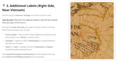
And near the South China Sea, just under the Tropic of Cancer and near where Hainan would be, you can spot:
“soure mayola” – likely a variant of Soure Manjola or possibly an early transcription error of Samar or another island.
“marague” – appears to refer to Marinduque or a nearby island (an early phonetic variation).
“calem” or “calin” – possibly a version of Calamianes or Calayan, located off northern Palawan/Luzon.
These Spanish-Portuguese transliterations are often approximate, but they reinforce the Philippine identity of the archipelago.
Neither Samar nor Marinduque (which Tim misspells as Marandue in the fake map detail) appear on this map. Tim admits his uncertainty in the above citations where he writes "possibly an early transcription error of Samar" and "appears to refer to Marinduque." He doesn't know. He isn't sure. What he does do is twist “soure mayola” to become Samar and “marague” to become Marinduquande with no linguistic support. What is "soure mayola" and "margue?" Those do not appear to be real words and do not show up in any language database I have used.
I ran this section through ChatGPT and received a completely different transcription and translation.
📜 Updated Image 2: Southeast Asia Context
Transcription (approximate):
Modernized Spanish:
En este lugar hay unaSierra de la AzemaraBoca de las Sierrasde Sierra Tormentosade Panacay una cordilleraque estáYacoteY. TumyedaTranslation (adjusted to new context):
In this place there is aSierra of AzemaraMouth of the Sierrasof Stormy Mountainsof Panacaand a mountain rangethat isYacoteIsland Tumyeda🧭 Geographic Interpretation
Sierra de la Azemara: Possibly a misunderstanding or transliteration of a local mountain range. The name "Azemara" is obscure, perhaps drawn from an indigenous or Arabic term. It might relate to Cambodian or Vietnamese highlands.
Sierra Tomentosa: "Stormy Mountains" — this is clearly a descriptive Iberian name, probably reflecting monsoonal conditions or treacherous geography.
Panaca: May be a native place name or distorted from a local kingdom or city. Could possibly relate to the Khmer or Malay regions.
Yacote: May correspond to Jakarta or Yakut—though the latter is Siberian and unlikely here, so Jakarta is more plausible phonetically.
Y. Tumyeda: “Y.” stands for Ysla (island). “Tumyeda” could be a corruption of a local name; possibly Temuyut, Timor, or a fictionalized rendering of an unfamiliar island in the area.
This kind of naming on 16th-century maps often mixes:
Local place names (phonetically transcribed)
Descriptive Iberian labels (e.g., "Sierra Tomentosa")
Guesses based on limited information from traders and explorers
Not only are these map portions illegible but using web inspector reveals that Tim has uploaded a much larger section of the map.

🔚 Conclusion: The Crown Drew the Line — And It Was Over the Philippines
When Diego Ribeiro — the Cosmógrafo Mayor of the Spanish Crown — labeled the Philippine islands as “Lequios”, he wasn’t speculating. He was drawing the official map of the empire, informed by firsthand maritime intelligence, Portuguese reports, and direct navigation accounts.
He named Luçonia (Luzon), marked Maniola (Manila), and wrote over the archipelago:
“Estas ysllas llaman Lequios...”“These islands are called Lequios...”
That is not a vague reference. That is a direct affirmation.
It was only later—through colonial reinterpretation, Jesuit editorial bias, and academic assumption—that “Lequios” was lifted off the Philippine map and misassigned to Ryukyu, despite the geographical, cartographic, linguistic, and ethnographic evidence to the contrary.
But history speaks in ink, not erasure. And the Smoking Quill writes again—this time with the Crown’s own cartographer as its witness.
I uploaded the portion of the map mentioning the Lequios to ChatGPT and asked for a transcription and translation.
📜 Image 1: Scroll Text (Top Banner)
Transcription (approximate):
Estas baxas tienē nombre por eld[e] bar los lequios assimesmose otras yslasModernized Spanish:
Estas bajas tienen nombre por elde bar los Lequios, asimismose [llaman] otras islasTranslation:
These shallows are named after thebar of the Lequios, likewiseother islands are [named so]🧭 Analysis:
The term “Lequios” refers to the Ryukyu Islands (modern Okinawa), which were called "Lequios" by Iberian sailors.
The reference to “baxas” (shallows) and naming suggests this label is not over the Philippines but possibly a navigational note referring to dangerous areas near the Lequios.
This section seems more maritime/navigation-related than territorial labeling.
That transcription and translation significantly differs from what Tim has written. Ribeiro did not write anything over the Philippine archipelago. The maps Tim perverts in this article are dated 1527 and 1529. The Philippine archipelago had not been mapped out at that time.
It was not until the 1540s that islands more or less recognizable as the Philippines began to appear on European world maps. The first Spanish cartographer to show Palawan and Mindanao was Santa Cruz, in his “Islario”; however, his knowledge was thin and inaccurate. The general shape of the islands was better delineated about 1551 by Sancho Gutiérrez, son of the older Diego Gutiérrez. His world map shows the chain of islands in general outline and in roughly the correct place; Sancho was in fact one of the cartographers called on to give an opinion on the position of the Philippines and the Moluccas, at Seville in 1566.
During 1564 and 1565, an expedition led by the Basque Miguel López de Legaspi visited the Philippines, and four charts made by pilots who accompanied that expedition are preserved at the AGI in Seville. They did not show much detail of the islands, however, and the first relatively detailed map was the one drawn about 1572 by Diego López Povedano. This showed the island of Negros in some detail, though in a very naïve way. In the map of the western Pacific Ocean compiled by Juan López de Velasco about 1575, the shape of the island was still very approximate, though this had been largely corrected in the printed version of this map published at Madrid by Antonio de Herrera y Tordesillas in 1601
Diego Ribeiro wasn't "drawing the official map of the empire" in 1529 as if it were a 100% accurate depiction of the region. Such a claim reveals Tim fundamentally does not understand this map. Tim's distortion of Ribeiro's map has created meaning where there is none.
This map and all the other 16th and 17th century maps Tim wrests demonstrates Europe's emerging knowledge of East Asia. These maps were constantly being revised. It's not a conspiracy to hide the Lequios Islands. Every single written journal, description, and eyewitness testimony places the Lequios Islands in the north near Japan, not in the Philippines. Timothy Jay Schwab's interpretation of these imprecise and incomplete maps is wrong. While he may not be intentionally misleading people, creating fake map details such as the one in this article is bound to confuse people who are not very discerning.


No comments:
Post a Comment